Some places don’t reveal themselves all at once. They ask for repetition—another walk, another set of eyes, another quiet moment where the forest decides what to show.
After last year’s GIS field trip in Palo Verde, I kept thinking about the Guayacan trail—not only because of the giant tree we met, or because we recorded hundreds of individuals in just 1.5 kilometers, but because it felt like we had only skimmed the surface of a story still unfolding. So we returned.
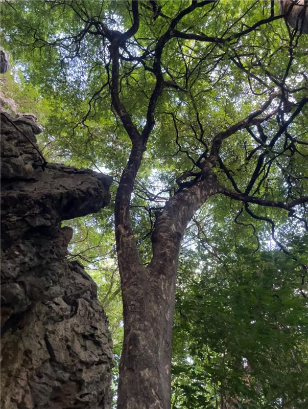
This time, the activity was familiar, but our focus was different: we came back to find the biggest Guayacan trees. The plan was straightforward and very “GIS”—use points from the previous database and revisit the largest individuals with measuring tape. But once we stepped onto the trail, the method evolved. We stopped looking only along the edge and began scanning deeper into the forest, guided by the unmistakable clues we had learned to recognize. Guayacan’s bark tells two different stories depending on age; juvenile and mature trees look nothing alike. With that in mind, older trees seemed to appear everywhere—almost as if they were calling to us from inside the forest and from higher up the hillside.
As we walked, students began noticing patterns we had missed before. The trees were not evenly scattered; they appeared in clusters, as if the forest had drawn invisible corridors of preference. Again and again, the largest individuals were on the slope, among limestone rocks, where soil is scarce and shallow. It felt counterintuitive—you don’t expect big trees to thrive where the ground seems to offer so little—yet those steep, stony patches appeared to be their favored home.
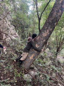
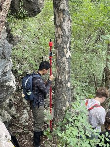
Measurements accumulated quickly. We recorded trees with more than 5 cm diameter at breast height (DBH, measured at 1.3 m above ground), and by the end of the trail we had 30 individuals meeting that threshold. The real surprise came at the upper end: seven trees measured more than 30 cm DBH.
Seven trees may not sound like many—until you remember how slowly this species grows. Those trunks represent thousands of years of resilience across a handful of living elders: quiet “grandparents of the forest” that have endured droughts, storms, fire, and centuries of pressure on tropical dry forests. Many were so heavily loaded with fruit that it was impossible not to step on them beneath their crowns. The ground felt alive with the next generation—seeds scattered everywhere, as if the forest were making a simple statement: we are still here.
None of this replaces formal ecological monitoring. But it does something powerful in education: it turns attention into practice, and practice into stewardship. A GPS track becomes a narrative line. A waypoint becomes an individual with history. And a species that is “endangered on paper” becomes something else in the field—a living population shaped by habitat, terrain, and time.
Guaiacum sanctum remains protected for a reason. Its wood is famously dense and historically exploited, and its habitat—tropical dry forest—remains among the most threatened ecosystems in the region. And yet, Palo Verde continues to surprise us: not by denying vulnerability, but by showing what protection can make possible when enough of the original forest story is allowed to persist.
We ended the walk the way we began—moving from point to point—but the feeling was different. The forest didn’t just confirm what we already knew; it added nuance, new questions, and a renewed sense that conservation is not only about preventing loss, but about noticing what remains and returning often enough to understand it.
A reminder that the forest keeps speaking—and when we come back, patiently and respectfully, it sometimes tells us more than we expected.